| . |
|
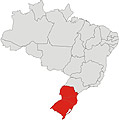
...The
south region of Brazil is divided in three states: Paraná, Santa
Catarina and Rio Grande do Sul. It covers 576,300.8 km ². The South
Region is the smallest. It is a great tourist, economic, and cultural
pole. It has a relatively high standard of living, with the highest
HDI of Brazil, 0.875 (2000), and the second highest per capita income
of the country, $10,723.60, behind only the Southeast Region. The region
also has a 98.7 % literacy rate. The region borders Uruguay, Argentina,
and Paraguay as well as the Center-West Region, the Southeast Region
and the Atlantic Ocean. |
|
| ...We
developing the greater and better south
of Brazil tourist
guide. See available cities: Gramado,
Canela. |
 |
|
|
|
-
State of Paraná |
|
flag
Brazil |
 |
| Capital
City: Curitiba |
| Population:
10.261.856 (2005) |
|
Area
(km2): 199.314,850 |
|
Number
of cities:
399 |
| Economy:
commerce, industry, services |
| Main
tourist destinations: Foz do Iguaçú,
Paranaguá, Ilha do Mel, Ponta Grossa, Morretes, Maringá
e Londrina. |
|
|
-
The state is divided in five natural areas: the seacoast,
the mountains near the sea (Serra do Mar) and three plateaus:
the first, the second and the third plateaus. All regions
reserve pleasant surprises. Nature and history in the coast;
progress and humanism in the capital located on the first
plateau; mystery and peacefulness in Vila Velha on the second
plateau; industry and agriculture in the North and Southwest;
the exciting waterfalls of Foz do Iguaçu where is
also located the Itaipu power plant, in the West, in Iguaçu
Falls. In the hospitality area, Paraná counts now
with 528 hotels and the services of approximately 977 travel
agencies with 1076 guides of tourism registered. |
|
|
 |
brazilian
map |
| |
|
-
State of Santa Catarina |
| Capital
City: Florianópolis |
| Population:
5.866.568 (2005) |
|
Area
(km2): 95.346,181 |
|
Number
of cities:
293 |
| Economy:
commerce, industry, services |
| Main
tourist destinations: Balneário Camboriú,
São Joaquim, São Francisco do Sul, Blumenau. |
|
|
-
A land of a thousand faces. Human faces, and faces of nature.
Located in southern Brazil between the states of Paraná
and Rio Grande do Sul, Santa Catarina is not easily defined.
This small Brazilian state, with a little more than 6 million
residents, unites within its unique 95 thousand km2 a diversity
of scenery and people that marvels visitors. From white
sand beaches, tropical forests and snowy mountains to Azorean
fishermen, Italian farmers, and German industrialists, this
is a land of beautiful, sharp and fascinating contrasts.
The balance and dynamism of the Santa Catarina economy are
reflected in high levels of growth, literacy, employment
and per capita income that are much above the national average.
These numbers surprise and complement the fascinating profile
of one of the most productive and beautiful Brazilian states.
|
|
|
|
| |
|
-
State of Rio Grande do Sul |
| Capital
City: Porto Alegre |
| Population:
10.845.087 (2005) |
|
Area
(km2): 281.748,538 |
|
Number
of cities:
496 |
| Economy:
Agriculture, cattle raising, industry |
| Main
tourist destinations: Gramado, Canela, Serra Gaúcha,
Missões, beach coast. |
|
|
-
Ecotourism is very popular in the Germanesque cities of
Gramado
and Canela;
their cold weather is among their attractions for internal
tourism. Tourism is also high in the wine regions of the
state, principally Caxias do Sul and Bento Gonçalves.
The pampas of the native Brazilian gaúcho are both
a national and international curiosity to tourists and their
customs are alive in the capital city of Porto Alegre as
well as in the cities of the "interior" or western
Rio Grande do Sul such as Santa Maria and Passo Fundo. The
state is also home to the historic São Miguel das
Missões, the ruins of an 18th century Jesuit Mission.
In the city of Nova Prata, in way the native bush, you find
a park thematic, with sources that gush out thermal waters
in a temperature of 41ºC, which possess excellent medicinal
properties and therapeutical. |
|
|
| -
Send us a message: |
| |
| |